Unlock the secrets of Turkey's captivating geography with our 2026 guide, perfect for Gen Z and Millennials. Discover how this unique nation bridges Europe and Asia, showcasing a stunning array of landscapes from the Black Sea's lush coasts to the Mediterranean's sunny shores and the Anatolian Plateau's vast expanses. Understand the strategic importance of its straits, the majesty of the Taurus and Pontic Mountains, and the historical rivers shaping its identity. This informational resource offers key insights into Turkey's diverse climate zones and its role as a regional powerhouse, highlighting essential features for travelers, students, and anyone keen to explore the physical map of this vibrant country. Prepare to navigate its compelling terrain with ease and gain a deeper appreciation for its natural wonders and geopolitical significance.
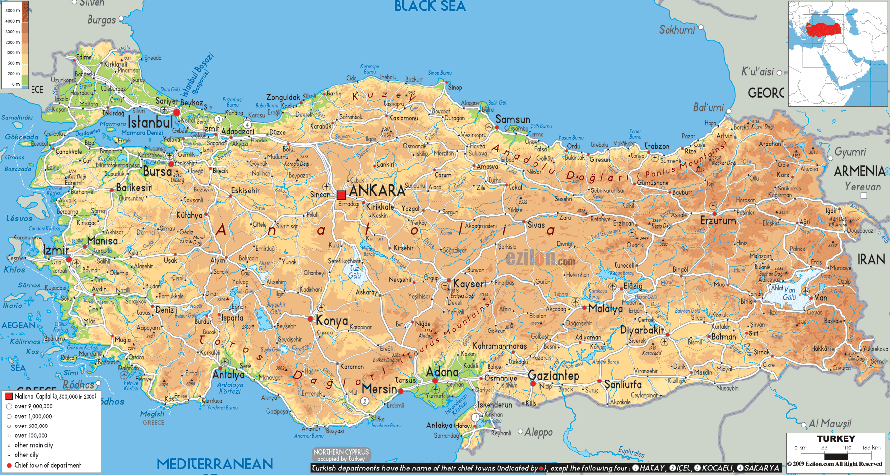
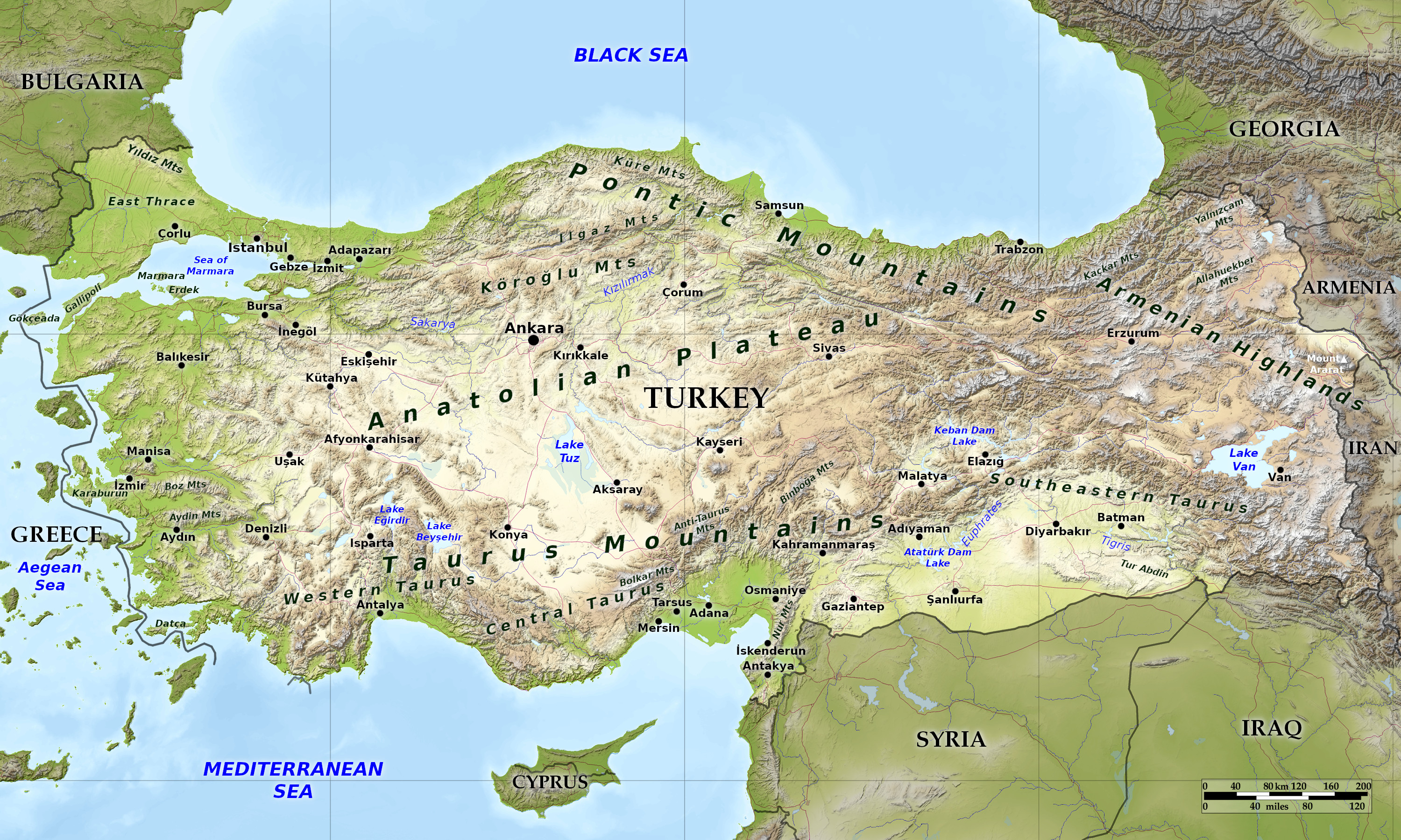
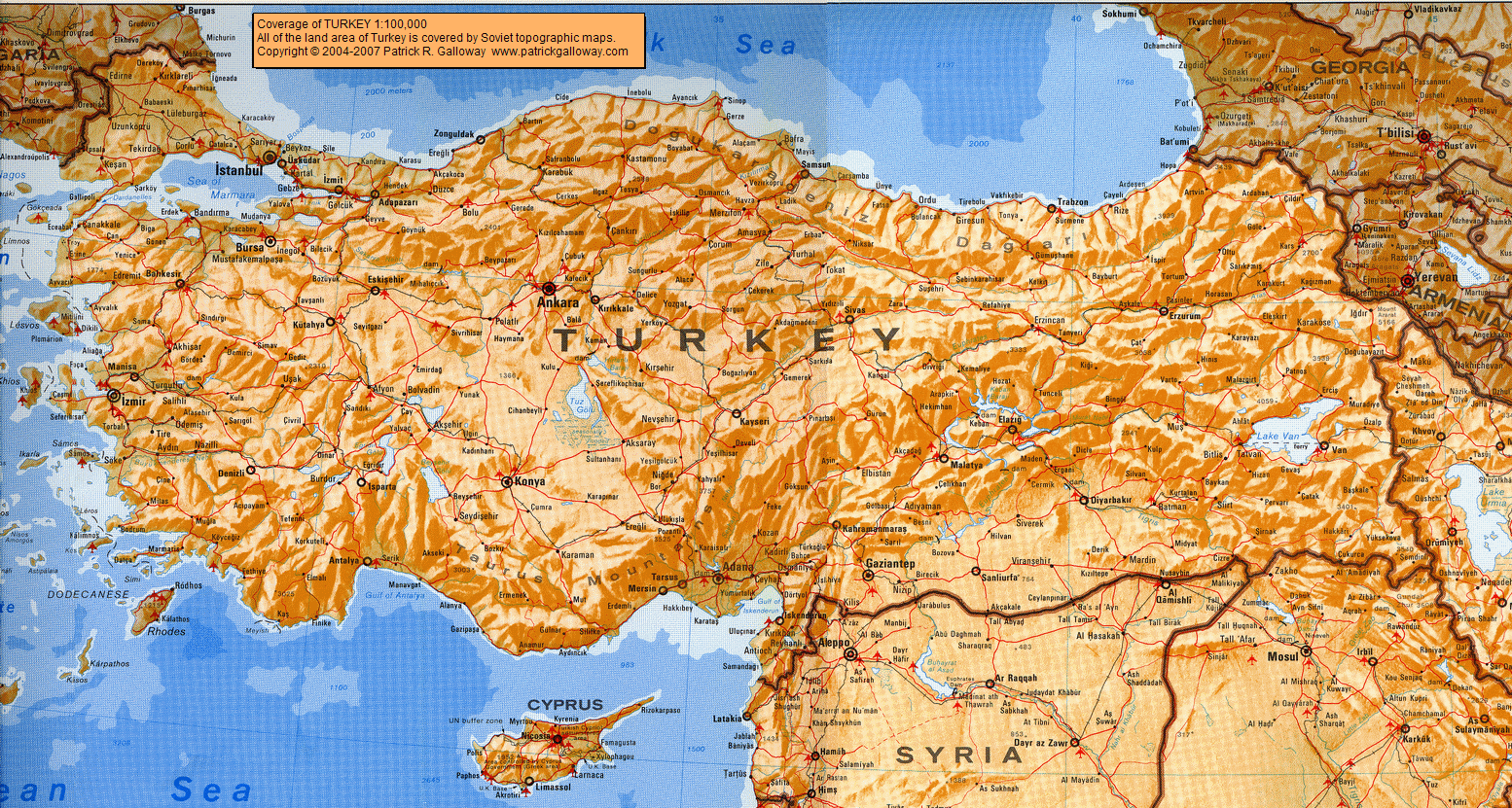
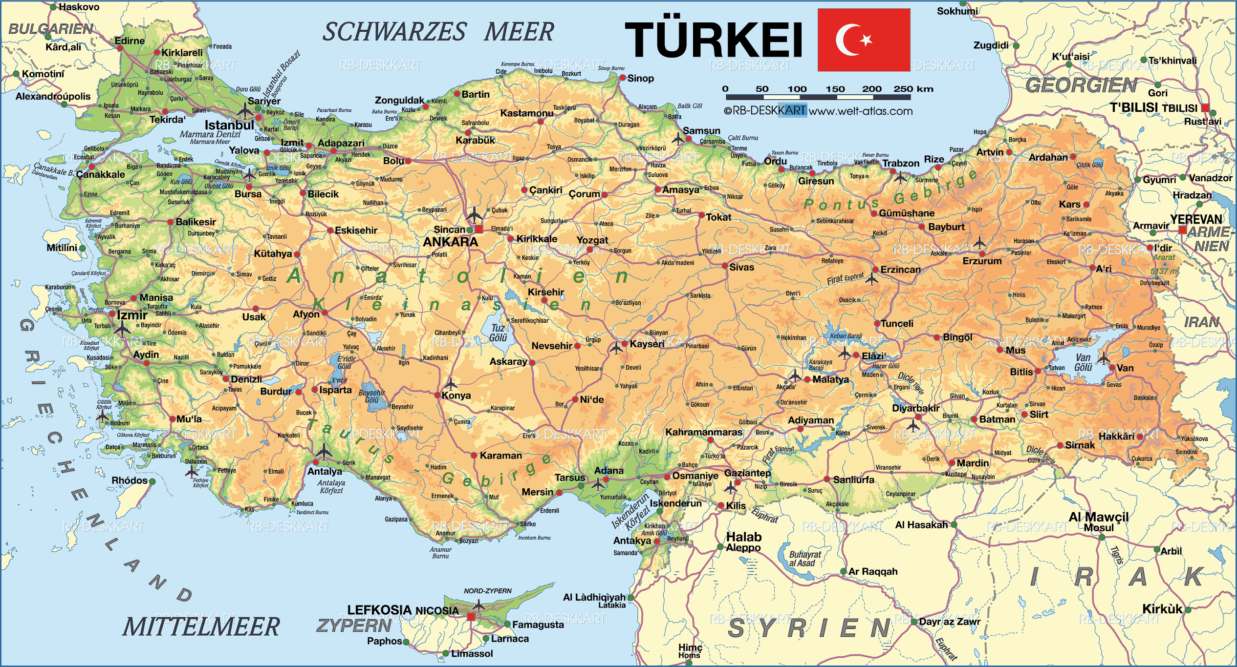
- What are Turkey's primary geographic features visible on a general map? - Turkey's general geographic map highlights its prominent Anatolian Plateau, bordered by the Pontic Mountains in the north and the Taurus Mountains in the south. The country is also framed by the Black, Aegean, and Mediterranean Seas, along with the strategically vital Turkish Straits, showcasing a diverse and impactful landscape.
- How do the Black Sea and Mediterranean Sea influence Turkey's climate geographically? - The Black Sea creates a humid subtropical climate along Turkey's northern coast, with abundant rainfall year-round. Conversely, the Mediterranean Sea brings a classic Mediterranean climate to the southern and western coasts, characterized by hot, dry summers and mild, wet winters, significantly impacting agriculture and tourism patterns across the regions.
- Where is the Anatolian Plateau located on Turkey's geographic map and what are its characteristics? - The Anatolian Plateau occupies the large central expanse of Turkey's geographic map, effectively making up most of the country's landmass. It's an elevated, semi-arid steppe region, typically experiencing continental climate extremes with hot, dry summers and cold, snowy winters, crucial for Turkey's grain production.
- What role do the Turkish Straits play in the country's geography and international importance? - The Turkish Straits, encompassing the Bosphorus and Dardanelles, are critical waterways on Turkey's map, connecting the Black Sea to the Mediterranean. Geographically, they represent a natural border and an indispensable maritime choke point, vital for global trade and geopolitical strategy due to their international shipping traffic.
- Which major rivers can be found on a geographic map of Turkey and where do they flow? - Key rivers on Turkey's geographic map include the Euphrates and Tigris, both originating in eastern Turkey before flowing into Mesopotamia. The Kızılırmak, Turkey's longest river, flows entirely within Anatolia. These rivers are crucial for irrigation, hydroelectric power, and agriculture across various regions.
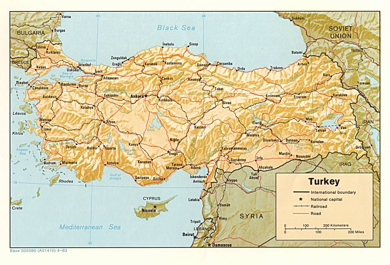
- What does the geographic map reveal about Turkey's border regions with neighboring countries? - Turkey's geographic map shows diverse border regions. To the east, mountainous terrain borders Armenia, Azerbaijan, and Iran. Southern borders with Syria and Iraq feature plains and valleys, while western borders with Greece and Bulgaria are more defined by rivers and hills. Its position is a bridge between continents.
- How does Turkey's varied topography, as seen on a geographic map, impact its biodiversity? - Turkey's varied topography, prominently displayed on its geographic map with coastal plains, high mountain ranges, and central plateaus, results in exceptional biodiversity. This range of ecosystems supports diverse flora and fauna, from temperate forests on the Black Sea coast to semi-arid species in the Anatolian interior, making it a biodiversity hotspot.
- What are the prominent mountain ranges visible on a detailed geographic map of Turkey?
- On a detailed geographic map of Turkey, the Taurus Mountains stretch across the southern part, while the Pontic Mountains line the northern Black Sea coast. These formidable ranges significantly influence regional climates and transportation routes.
- Where can I locate the major bodies of water surrounding Turkey on a geographic map?
- You'll find the Black Sea to the north, the Aegean Sea to the west, and the Mediterranean Sea to the south. The internal Sea of Marmara connects the Black and Aegean through the Dardanelles and Bosphorus straits.
- How does Turkey's geographic position affect its climate zones on the map?
- Turkey's unique geographic position, with vast mountain ranges and coastal exposure, creates diverse climate zones. The coasts feature Mediterranean and Black Sea climates, while the interior is characterized by a continental climate with hot, dry summers and cold, snowy winters.
- What are the key straits that appear on a geographic map of Turkey and why are they important?
- The Bosphorus Strait and the Dardanelles Strait, collectively known as the Turkish Straits, are crucial waterways connecting the Black Sea to the Aegean Sea and beyond. They are vital for international shipping and trade, making them geopolitically significant.
- Can you identify major plateaus and plains on a geographic map of Turkey?
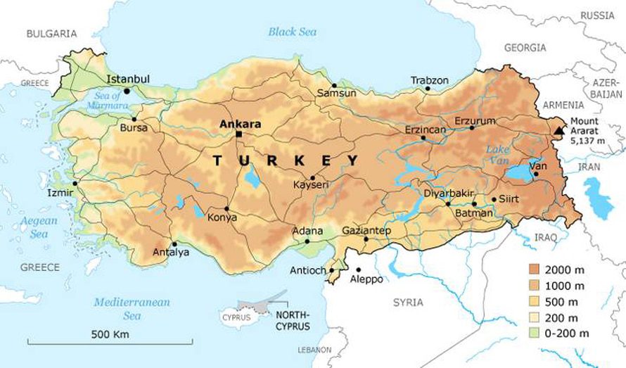
- Yes, the vast Anatolian Plateau dominates central Turkey, characterized by semi-arid steppes. Coastal plains, like those in the Mediterranean and Aegean regions, are highly fertile and important for agriculture, often visible as green areas on a map.
- What is the highest point on a geographic map of Turkey?
- The highest point on any geographic map of Turkey is Mount Ararat, an impressive stratovolcano located in the far eastern region. Standing at 5,137 meters (16,854 feet), it is a significant landmark with historical and cultural importance.
- How does the geographic map of Turkey illustrate its connection between Europe and Asia?
- The geographic map clearly shows Turkey as a transcontinental country. Its small European portion, Thrace, is separated from the larger Asian portion, Anatolia, by the Bosphorus Strait, the Sea of Marmara, and the Dardanelles Strait, visually bridging the two continents.
Welcome to your essential guide to the geographic map of Turkey in 2026. This stunning nation, a true bridge between continents, offers an incredibly diverse landscape that's crucial to understand for anyone exploring its rich culture, history, or natural beauty. From sun-drenched Mediterranean beaches to snow-capped eastern peaks and the vital waterways that separate Europe from Asia, Turkey's geography tells a compelling story. Get ready to dive into the key features that define this remarkable country, perfect for quick insights on the go.
Frequently Asked Questions
Where are the key geographic features on Turkey's map?
The key features include the **Taurus Mountains** in the south, **Pontic Mountains** in the north, the central **Anatolian Plateau**, and coastlines along the **Black Sea**, **Aegean Sea**, and **Mediterranean Sea**. The **Turkish Straits** are crucial.
How can Local MAP or Maps help navigate Turkey's diverse terrain?
Pull up your preferred mobile Maps app to verify real-time routes through mountainous regions or coastal roads. Use Local MAP features to pinpoint national parks, historical sites, and major cities like Istanbul or Ankara. Check-in tips often include road conditions and accessibility.
What are the best times to explore Turkey's varied geographic regions?
For coastal regions (Aegean, Mediterranean), late spring (April-May) and early autumn (September-October) offer pleasant weather. Central Anatolia is best in spring or early fall to avoid summer heat and winter snow. Eastern mountain areas are ideal in summer.
Quick Local Guide Table or Scannable List
- **Region:** Mediterranean Coast
- **Neighborhood / Cross-streets:** Antalya / Fethiye
- **Region:** Black Sea Coast
- **Neighborhood / Cross-streets:** Trabzon / Rize
- **Region:** Central Anatolian Plateau
- **Neighborhood / Cross-streets:** Cappadocia / Ankara environs
- **Region:** Eastern Anatolia Mountains
- **Neighborhood / Cross-streets:** Mount Ararat / Van Lake area
- **Region:** Aegean Coast
- **Neighborhood / Cross-streets:** Izmir / Bodrum
All maps focus on geographic map of turkey
Turkish Straits, Anatolian Plateau, Black Sea, Mediterranean Sea, Aegean Sea, Taurus Mountains, Pontic Mountains, Euphrates River, Tigris River, Sea of Marmara, Mount Ararat, diverse climate zones, strategic land bridge Europe Asia.



Geographic Map Of Turkey Country Report Turkey Scaled . Turkey Geography Map Turkey Map With Cities EVXAGG Turkish Physical Map . Geography Of Turkey Wikipedia 500px Turkey Topo . Printable TURKEY Political Map And 2 Bonus Topography Roads Etsy Il Eer9 . Geography Map Of Turkey Turkey Physical Map




About Turkey Geography Marmaris Turkey Official Website Turkey Map 01 . Physical Map Of Turkey Large. Blue Green Atlas The Geography Of Turkey Relief Map Of Turkey . Turkey Political Geography Turkiye Map Of Turkey And Surrounding Countries 2024 . Map Of Turkey Turkey Wikipedia


Turkey Geography Turkey Map Map Geography Map . Turkey Map Region Geography Political Geographic 3D Turkey Map Region Geography Political Geographic 3d Model. Large Physical Map Of Turkey Turkey Asia Mapsland Maps Of The World Large Physical Map Of Turkey . Map Of Turkey Vector Map Of Turkey Country . Unveiling Turkey A Geographic Journey Turkey Hd Map


Geography And Climate Of Turkey At Mary Bevis Blog Turkey Map Physical 0 . Geography Map Of Turkey 152261184 Stock Photo Geographic Map Of Turkey With . Designated Study Points Depicted On The Physical Map Of Turkey Designated Study Points Depicted On The Physical Map Of Turkey . Turkey Borders What Sea Turkey Geography . Turkey Map By Nat Geo Maps Folded Buy Online At The Nile




Maps Of Turkey Detailed Map Of Turkey In English Turkey Satellite Map . Regions Of Turkey Mappr . Trains Of Turkey Maps Maps Turkey Map 2002 Jpc2 . Turkey Maps Facts World Atlas The Times Map Of Turkey . Turkey Median Age 1960 2026 True Size On The Map Turkey



Turkey Political Geography Political Map Of Turkey 2006 2 Small . Geography About Turkey A New Map Of Turkey In Europe State Borders Turkey Map 730px 02 F583a57cba . Geography Map Of Turkey . Highlighted Infographic Map Of Turkey Ideal For Education Highlighted Infographic Map Of Turkey Ideal For Education Travel Guides And Geography Free Vector . Hi Everyone I Made This Map Showcasing The Fascinating History And Ethnic Map Of Turkey V0



Turkey Geography Complete Guide Physical Features Explained YouTube . Features Turkey At Jason Lindstrom Blog Turkey Coverage . Istanbul Canal Project Map Istanbul Map Turkey . Exploring Turkey Through Its Map A And Cultural Guide Turkey Map 768x525 . Map Of Turkey Turkey Map Physical