Planning a journey to New Zealand's stunning South Island? For United States travelers, understanding the geography and best routes is essential for an unforgettable adventure. A comprehensive map of the South Island acts as your ultimate guide, revealing everything from the majestic Southern Alps to the serene fjords of Fiordland National Park. Discover major cities like Queenstown, Christchurch, and Dunedin, along with their unique attractions. Learn how to plot scenic drives, locate hidden gems, and access world-class outdoor activities such as hiking, kayaking, and skiing. This guide provides U.S. visitors with crucial insights into navigating the diverse landscapes, ensuring you make the most of your trip. Whether you are looking for adrenaline-pumping experiences or tranquil natural beauty, a detailed South Island map is your first step to unlocking this incredible destination, helping you plan your itinerary effectively and explore with confidence.
What are the must-see natural attractions on New Zealand's South Island?
The South Island is rich with natural wonders. Essential stops include Milford Sound and Doubtful Sound in Fiordland National Park, the dramatic glaciers of Franz Josef and Fox, the majestic Southern Alps including Aoraki Mount Cook, and the vibrant blue waters of Lake Tekapo. Each offers unique scenery and activities, from scenic cruises to exhilarating hikes, making them top priorities for U.S. visitors exploring the region.
How long does it take to drive across New Zealand's South Island?
Driving across the South Island varies greatly depending on your starting and ending points, and the route chosen. A direct drive from Christchurch to Queenstown can take around 6-7 hours. However, to truly experience the island's beauty and numerous attractions, planning at least 7-10 days is recommended for a comprehensive road trip, allowing time for scenic detours and activities, rather than just covering distance.
Which cities are ideal starting points for a South Island road trip for U.S. travelers?
For U.S. travelers, Christchurch and Queenstown are the most common and convenient starting points for a South Island road trip. Christchurch offers international airport access and is a good base for exploring the east coast and central alps. Queenstown provides immediate access to the adventure capital and the stunning southern lakes region, also with an international airport connection.
What is the best way to get a detailed map of New Zealand's South Island?
You can obtain detailed maps of New Zealand's South Island from several sources. Physical maps are available at major airports, tourist information centers throughout New Zealand, and bookstores. Online, you can find digital maps through Google Maps, Waze, and dedicated New Zealand travel apps. Many rental car companies also provide complimentary maps. Combining physical and digital resources offers the best navigational coverage.
Are there any specific driving considerations for U.S. tourists on the South Island?
Yes, U.S. tourists should note that New Zealand drives on the left side of the road. Roads, especially in mountainous or rural areas, can be narrow, winding, and unpaved. Always adhere to speed limits, which are in kilometers per hour. Allow extra travel time for scenic stops and unexpected delays. Watch for livestock on rural roads and be prepared for rapidly changing weather conditions, particularly in alpine regions.
Exploring New Zealand's South Island with a MapThe South Island of New Zealand offers an incredible array of landscapes, from dramatic mountains to pristine coastlines, making it a dream destination for travelers from the United States. Successfully navigating this vast and varied terrain requires a reliable map. A detailed map provides an indispensable tool for planning your adventure, ensuring you can locate key attractions, understand travel times between destinations, and discover lesser-known spots that will make your trip truly unique.
Understanding the layout of the South Island is the first step toward crafting an unforgettable itinerary. Whether you are seeking adventure sports, serene natural beauty, or vibrant city experiences, a map helps you connect the dots. It is more than just a piece of paper; it is your gateway to exploration, allowing you to visualize your journey and make informed decisions about your route and activities.
For U.S. visitors, especially those accustomed to extensive road networks, realizing the scale and sometimes rugged nature of New Zealand's roads is important. A good map highlights road conditions, major highways, and even points of interest along your chosen path. It becomes your silent companion, guiding you through an island rich in culture and breathtaking vistas.
Understanding the Geography of NZ South Island
New Zealand's South Island is renowned for its diverse geographical features. Dominating the landscape are the Southern Alps, a spectacular mountain range running almost the entire length of the island. These mountains are home to Mount Cook, New Zealand's highest peak, and numerous glaciers, including the Fox and Franz Josef glaciers. The west coast is characterized by lush rainforests and dramatic fjords, while the east coast offers expansive plains and charming coastal cities.
A map clearly illustrates these distinct regions, allowing you to pinpoint where the mountains give way to fertile farmlands or where the rugged coastline transitions into golden beaches. This geographical understanding is crucial for planning activities, as different regions cater to different interests. For instance, the southwest is ideal for fjord cruises and hiking, while the central alpine regions are perfect for mountaineering and skiing.
Beyond the major landforms, a map helps identify the extensive network of rivers and lakes that crisscross the island. These waterways are often central to many recreational activities, from jet boating and kayaking to fishing. Familiarizing yourself with these natural elements through a detailed map enhances your appreciation of the island's unique environment and aids in planning water-based excursions.
Key Cities and Regions to Explore
The South Island boasts several major cities and distinct regions, each offering unique experiences. Christchurch, often called the Garden City, serves as a gateway to the Canterbury Plains and offers a vibrant arts scene. Queenstown, the adventure capital, sits amidst stunning mountains and Lake Wakatipu, providing endless thrills. Dunedin, with its Scottish heritage, features impressive Victorian architecture and a rich cultural scene.
Beyond the cities, regions like Fiordland National Park are must-sees. This UNESCO World Heritage site is famous for Milford Sound and Doubtful Sound, dramatic fjords carved by glaciers. A map helps outline the challenging but rewarding drives into these remote areas and highlights visitor centers and scenic viewpoints. The Otago region is known for its gold mining history and Central Otago wine region, easily locatable on any detailed map.
For those seeking coastal beauty, the Marlborough Sounds in the north offer intricate waterways perfect for cruising and kayaking, while the Abel Tasman National Park is famous for its golden beaches and coastal tracks. Each of these regions presents a unique facet of the South Island, and a map is instrumental in navigating between them and appreciating their individual charms. Pinpointing services like petrol stations, accommodation, and dining options also becomes easier, crucial for remote areas.
Utilizing Your Map for Trip Planning
Effective trip planning for the South Island begins with a good map. Start by identifying your primary points of interest, whether they are specific national parks, cities, or adventure activities. Use the map to plot a logical route that minimizes backtracking and maximizes your travel efficiency. Consider the distances between locations and estimate driving times, as roads can be winding and mountainous.
A map is invaluable for identifying accommodation options, petrol stations, and emergency services, particularly when venturing into more remote areas. It helps you understand the availability of amenities along your chosen route, allowing for better preparation. Many maps also indicate hiking trails, scenic lookouts, and picnic spots, providing opportunities for spontaneous stops and discoveries.
Beyond navigation, a map can serve as a historical and cultural guide, sometimes marking historical sites or areas of significant Māori heritage. Integrating these elements into your itinerary enriches the travel experience, offering a deeper understanding of New Zealand. Always carry a physical map alongside any digital navigation, as cell service can be intermittent in isolated parts of the South Island.
Common Questions About Navigating NZ South Island
Travelers often have many questions about navigating New Zealand's South Island, especially concerning routes, travel times, and must-see locations. A common inquiry focuses on the best driving routes. The Great Alpine Highway (State Highway 73) across Arthur's Pass offers spectacular mountain views, while State Highway 6 along the west coast is famous for its glaciers and rugged coastline. Planning these on a map helps anticipate challenges and allocate sufficient time.
Another frequent question relates to the best time of year to visit. While maps do not directly answer this, they can help you understand seasonal road closures or accessibility to certain areas, especially in winter. For example, some mountain passes might be subject to snow, which a map can help you identify. Always check local road conditions and weather forecasts in conjunction with your map.
Finally, many U.S. visitors ask about connecting the South Island's main attractions. A map makes it clear how to link cities like Queenstown, Wanaka, and Te Anau, or how to combine a visit to the Marlborough wine region with a journey down the east coast. Strategic use of your map allows you to create a seamless travel flow, ensuring you hit all your desired destinations without unnecessary detours or rushed experiences.
South Island New Zealand travel guide, NZ South Island scenic driving routes, planning a New Zealand trip for U.S. citizens, major attractions South Island map, best places to visit New Zealand South Island, navigating Fiordland National Park, Queenstown adventure map


Map Of New Zealand South Island ToursMaps Com Map Of New Zealand South Island 1 . Map Of South Island New Zealand Regions Map Of South Island New Map Of South Island New Zealand Regions . Detailed Map Of South Island New Zealand With Other Marks New Detailed Map Of South Island New Zealand With Other Marks Small . South Island Map South Island New Zealand ROAD TRIP PLANNER 2025 South Island Road Trip Guide New Zealand. New Zealand S South Island Holidays 2026 2027 P64 South Island With


Just Our Pictures Of New Zealand South Island Map And Trip Itinerary Map1aa . Map Of New Zealand South Island AU NZ Travel Map Of New Zealand South Island AUNZTravel . Map Of South Island New Zealand Com 435 . South Island New Zealand Map Com Squarespace . Map Nz West Coast South Island At Tara Brothers Blog South Island Map


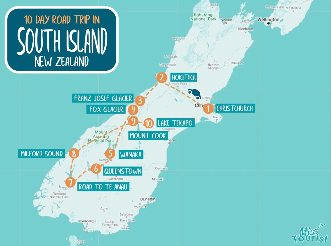

The BEST New Zealand Road Trip Itinerary In 2026 New Zealand South Island Road Trip Map . Map Of South Island New Zealand Com South Island . Map New Zealand South Island Com South Island Map Thumbs 1 . Road Map South Island New Zealand Update To Our South Island Driving . New Zealand In 1 Week 7 Days Road Trip Itinerary Both Islands MAP28 High Resolution South Island South Island Tourism New Zealand Feature Mandatory Credit Tourism New Zealand


Map Nz West Coast South Island At Tara Brothers Blog Route Map South Island V1.1 . South Island Map New Zealand Road Maps South Island Map . New Zealand South Island And Political Map Stock Vector New Zealand South Island And Political Map J3CAY1 . A Month In Nz Map Of The South Island South3 . Blue Green Atlas Free Relief Relief Map Of New Zealand South Island New Zealand South Island Adventure Itinerary Map 2


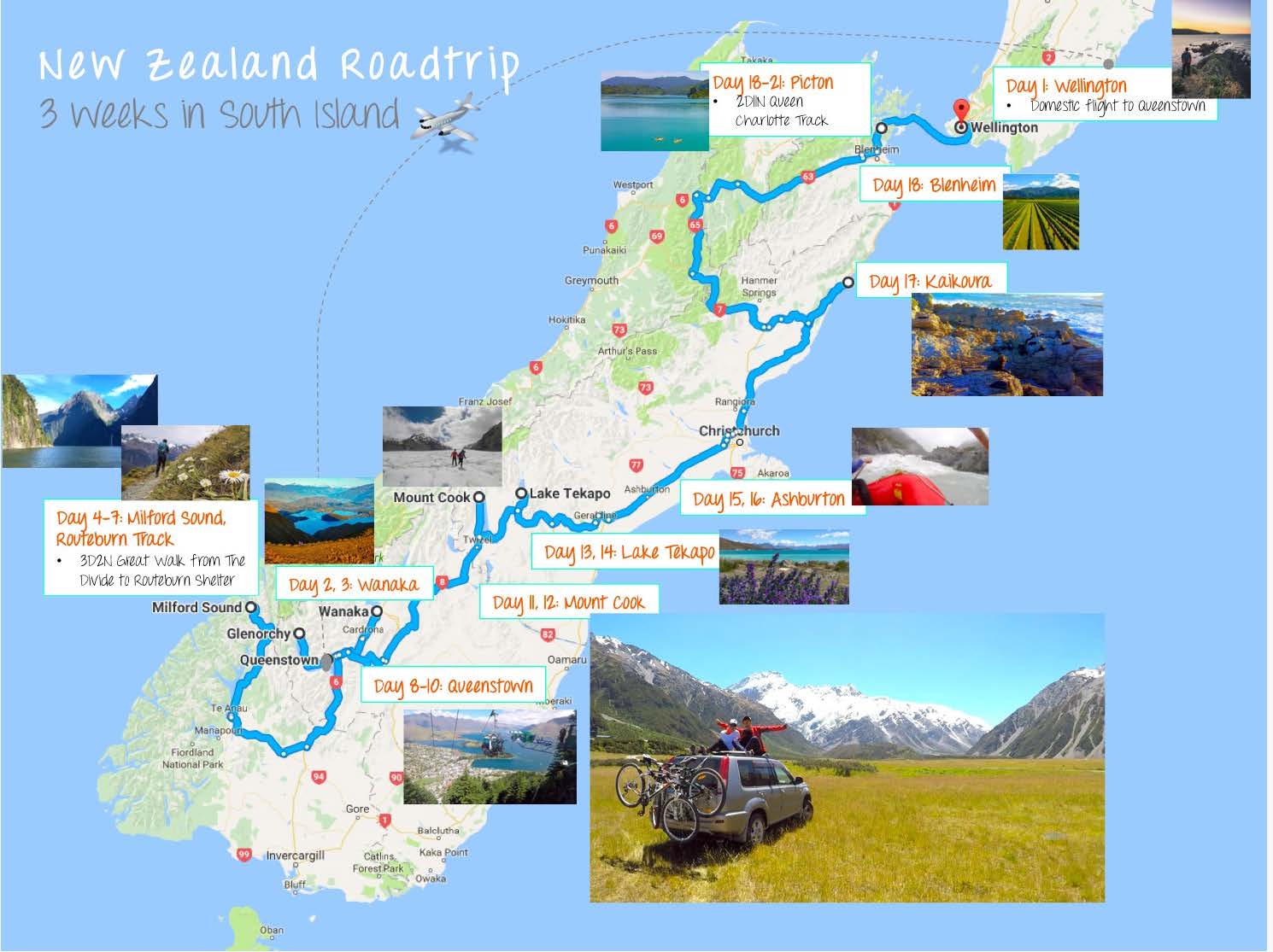


New Zealand Travel Map . New Zealand Map South Island Road Map New Zealand South Island Itinerary Map . 3 Weeks In New Zealand South Island Our Itinerary NZ Itinerary . South Island New Zealand Map Maps Nz Itinerary . South Island New Zealand Map Printable Free Map Printable South Island New Zealand Map Printable


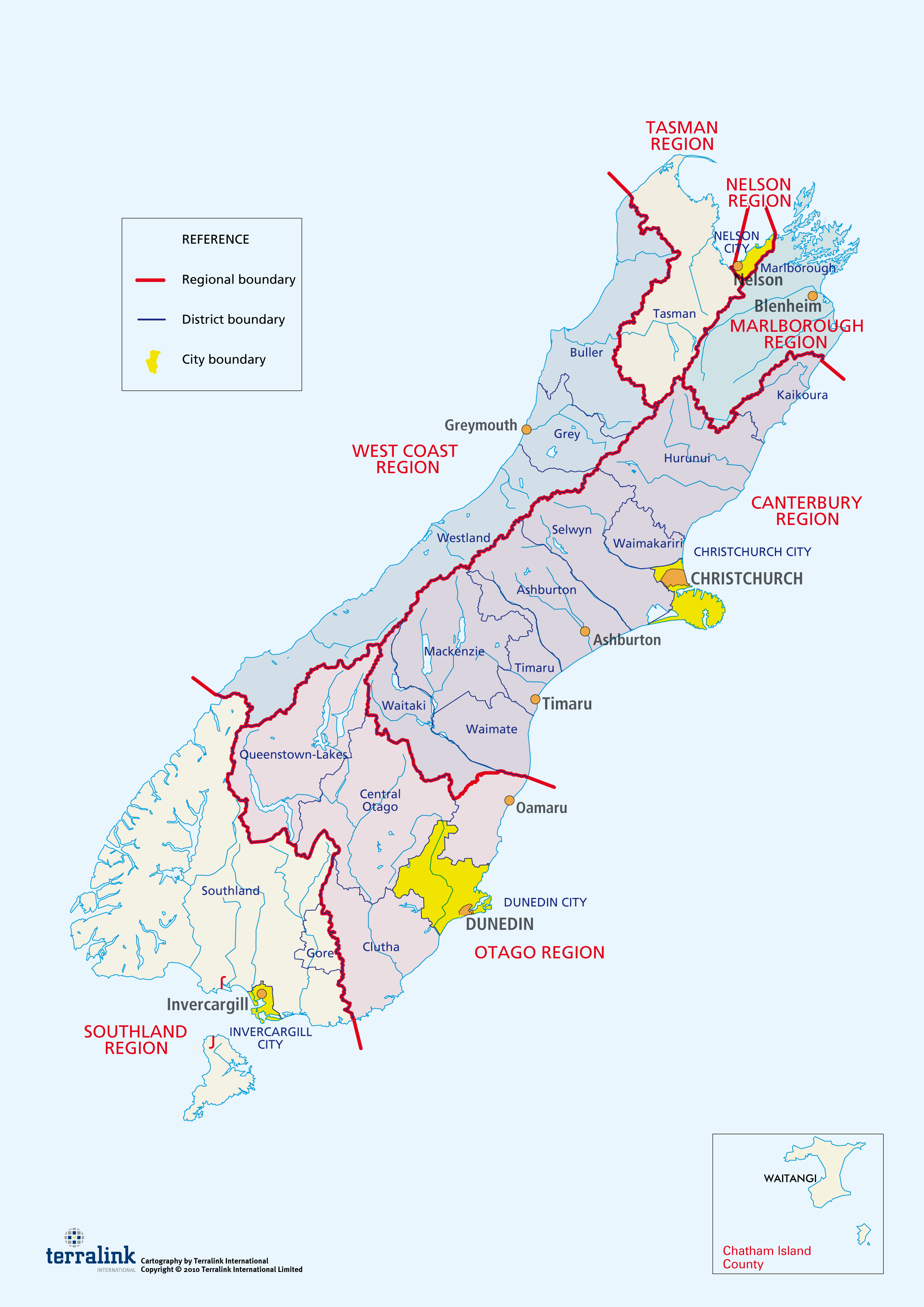

Map Of New Zealand New Zealand Map With Cities Towns And Regions Political Map Of New Zealan . Large Detailed Map Of New Zealand With Cities New Zealand Oceania Large Detailed Map Of New Zealand With Cities . Physical Map Of New Zealand Ezilon Maps New Zealand Physical Map . Distrikty Na Nov M Z Landu Wikipedie South Island PNG.PNG. Map Of North Island Nz North Island New Zealand Map OVMN Northisland Physical Map


The Best New Zealand Group Tours 2025 2026 . Road Map South Island New Zealand Nz South . South Island Map South Island New Zealand ROAD TRIP PLANNER 2025 Large Scale Map Of South Island New Zealand With Relief Marks Of All Cities Roads Railroads And Other Marks . Google Maps New Zealand South Island ToursMaps Com Turbid Waters Surround New Zealand Crop . Map New Zealand South Island Com Map New Zealand South Island 1